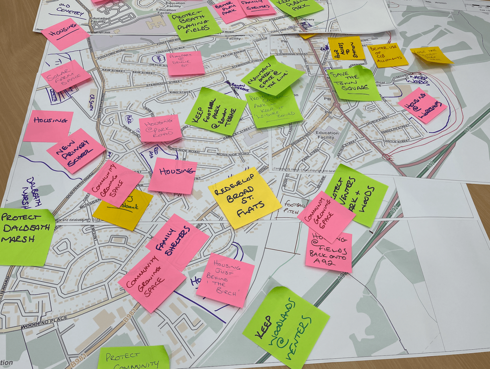
Published January 2026
Compiled by Stuart Duffy for My Cowdenbeath CIC
Feedback and comments welcome – Email: feedback@mycowdenbeath.scot
CONTENTS
- Introduction
- Statement of Proposals
- 2 a) Context
- 2 b) Key Themes
- 2 c) Format
- 2.1 Connected Spaces
- 2.2 Community Assets
- 2.3 Parks & Green Spaces
- 2.4 Future Development Spaces
- 2.4.1 Central Park blaze pitches (Chapel St)
- 2.4.2 Housing development east of the ‘Fish Tail’
- 2.4.3 Housing development at Sinclair Drive red blaze pitch
- 2.4.4 Housing development south of Copeland Crescent
- 2.4.5 Housing west of B917 at Kirkford Pit
- 2.4.6 Housing development east of Watson Street
- 2.4.7 Beath Cemetery extension
- 2.4.8 MUGA at the Skatepark
- 2.4.9 Community Hub at Sinclair Drive
- 2.4.10 Little Raith destination attraction
- 2.4.11 Neighbourhood parking expansion
- 2.4.12 Deposit Return Scheme drop-off points
- 2.4.13 Community-run filling station
- 2.4.14 Community-run eCharging station
- 2.4.15 New playpark provision
- 2.4.16 Potential sites for new school provision
- 2.4.17 Broad Street bus garage development
- References
- Appendix
Last updated: 7th Jan. 2026

1. Introduction
1.1 What is a Local Place Plan
Local Place Plans (LPP’s) are a new idea to allow communities to have a greater say in how land and buildings are developed in their area. They play an important role in the planning system and, when adopted by the planning authority (Fife Council in our area), they are used as a ‘material consideration’ for any planning matters or future developments in that community.
The LPP also helps inform the Local Development Plan (LDP), which is a plan for land use created for the region by Fife Council. The local authority will soon update the LDP for Fife. The LDP is guided by the National Planning Framework (NPF4) which contains a number of important policy themes and aims to create a model set of rules and aims for community development across Scotland, set by the Scottish Government.

Local Place Plans and the Local Development Plan deal with how land and buildings could be developed in the area.
Actions around how strategic objectives are met, such as fighting poverty or improving facilities for example, are evidenced in the Locality Plan, which is a plan created and owned by Fife Council. In Cowdenbeath, this is the Plan 4 Cowdenbeath, developed by the Cowdenbeath Area Committee and published in early 2024.
Communities can contribute to this Locality Plan through Community Action Plans (CAPs) and in Cowdenbeath our CAP was previously developed by Coalfields Regeneration Trust (2019-2024). A new plan will be developed involving community stakeholders from 2026-2036 by My Cowdenbeath CIC.

1.2 Definition & Boundary
This Local Place Plan (LPP) has been prepared by My Cowdenbeath CIC and relates exclusively to the town of Cowdenbeath in Fife, and is identified by the community council boundary as defined at 1st May 2024.
The boundary map below defines the area of this LPP, from Mossmorran and the Little Raith Wind Farm in the South, to Cantsdam and Leuchatsbeath in the North. The community council boundary sits in between neighbouring villages of Lumphinnans to the East and Hill of Beath to the West. As part of the formal consultation, the Plan will also be shared with these community councils and elected members covering the areas of Kelty, Kingseat, Crossgates & Mossgreen, Aberdour, Auchtertool and Lochgelly.

1.3 ‘Community Body’ test
My Cowdenbeath CIC is a community interest company, registered in Scotland with company no. SC731539. Our Articles of Association are available to view here.
Only certain types of organisation can complete and submit a Local Place Plan for their community. They are known as a ‘community body’.
‘Circular 1/2022: Local Place Plans’ defines an authorised ‘community body’ as:
a) a community-controlled body within the definition given in section 19 of the Community Empowerment (Scotland) Act 2015, or
b) a community council established in accordance with Part 4 of the Local Government (Scotland) Act 1973.
My Cowdenbeath CIC qualifies as a community body as we meet the test of being a ‘community-controlled body’ as defined in the Community Empowerment (Scotland) Act 2015, evidenced in our Articles of Association linked above. This was further confirmed by Fife Council in communication from their Planning Team on 25th July 2025.
Cowdenbeath residents overwhelmingly support a resident-led community regeneration and development body for the town. In a survey of 1,126 residents between July and September 2023, 75% were supportive of the creation of the My Cowdenbeath development company (23% undecided, 2% Not Supportive). 70% agreed with the key development themes laid out in the My Cowdenbeath website (28% undecided, 2% disagree).
1.4 History & Heritage
Cowdenbeath evolved over centuries from sparsely-populated farmland, to the establishment of Beath Kirk creating the parish in 1429. By 1643 the Parish of Beath was separated from its neighbour Dalgety Bay & Aberdour by Rev. John Row, of Carnock. Around 100 families lived in the area according to records from 1790 and by 1820 the town had grown to become an important staging point on the route between Edinburgh and Perth.
By 1850 a collection of local farms within the growing parish were divided into four districts, one being named Cowdenbeath and locals eventually agreed on this as the name for the expanding town. But it was the arrival of the Oakley Iron Company that sealed the fate of the town, making its name in mining for the next 100 years.

Cowdenbeath became a formal Burgh in 1890, quickly developing a ‘boom-town’ reputation for the mining industry through much of the 19th and early 20th century. The town was dubbed the ‘Chicago of Fife’ due to its rapid population expansion, from 100 families in 1790 to around 4,000 people in 1890, and doubling to more than 8,000 just a decade later in 1900. This rapid expansion brought an increase in demand for housing, the development of local industry and services to support the increasing population, including new schools, factories, shops and a town council chambers.
By the 1970’s though, the pits had closed and the coal industry was in serious decline nationally as a result of political decisions, harming the Cowdenbeath area for decades to come. The town has struggled to recover economically, with the businesses in Cowdenbeath today being a mix of retail and personal services in our town centre, and small independent businesses across the five industrial estates in the boundary (Fordell, Woodend, Thistle, Gateside & Glenfield) and at the former engineering base at Woodend Business Centre.
Cowdenbeath continues to support the retail and service needs of the neighbouring communities of Lochgelly, Crossgates, Hill of Beath, Kelty, Lumphinnans, Lochore and Benarty with its excellent bus network and free town centre parking (one of the last remaining free parking places in Fife). The town has a deep and strong affinity with these neighbouring communities, which make up the modern Council locality of ‘Cowdenbeath Area’. The town is used by many more people from across the area to shop, work and visit.
Notable leisure pursuits for today’s 12,000 population include the Cowdenbeath Leisure Centre, recently opened after an £8m refurbishment, as well as a busy community centre, social clubs, bowling clubs and the Racewall – the home of Scottish stock car racing, based at Central Park.
Poverty has been a key limiting factor in the prosperity of our town for a number of decades and continues to be a challenge, with the recent cost of living crisis and lower educational attainment adding to the challenges we face.

Cowdenbeath has a lower attainment at Nat5 level with 4 or more passes at 14.2% (Fife 28.3%). Less young people head into Higher Education (25%) compared to Fife as a whole (35.8%). More young people went direct into employment after school at 29.6% compared to Fife as a whole at 23.4%. This reflects the need for school leavers to get out to work to earn a wage to support the household, which can already be struggling.
Cowdenbeath has more school children eligible for free school meals (24.4%) compared to Fife (19.3%) and Scotland as a whole (18.6%).
According to the latest statistics available, around 22% of the population of Cowdenbeath live in the Most Deprived 20% SIMD postcodes in Scotland.
Cowdenbeath had 4.3% of adults aged 16-64 claiming out of work benefits at June 2023, compared to 3.4% for Fife as a whole.
78% of Cowdenbeath’s adult population were classed as ‘economically active’ in 2022-23 (men at 88.5% and women at 67.6%). This difference reflects both the number of women of working age who are on maternity leave, and also the traditional role of ‘homemakers’ in some families.
Business density of 251 enterprises per 10,000 residents was the lowest in Fife during 2023 and well short of the Scottish Government target of 375 businesses per 10,000 population, however vacant business space is one of the lowest in Fife averaging 15% in 2023. This highlights the potential for further business development or the refurbishment of abandoned properties, in the town centre especially, to encourage growth and move towards a higher business density for the population size.
Tackling poverty, raising aspiration and engaging with the local community to improve resilience to these challenges are some of the main priorities of the Cowdenbeath Area local team within Fife Council. Their recently updated Plan 4 Cowdenbeath outlines a number of priorities and aims to demonstrate positive action for our community across broad themes.
Consideration of the Fife Local Plan 2017 was also part of our work in creating this Local Place Plan.

Cowdenbeath’s Town Centre was designated in the Fife Local Plan 2017 as having 3 distinct zones – a core retail area, secondary shopping area and wider town centre area. These zones have changed significantly since 2017 and we would argue the core retail area zone must extend north to include the Lidl and B&M development and shops in the north of the High Street to bring renewed investment and focus across the town centre.

1.5 Creating the Local Place Plan
A requirement of any LPP is to define how the community have been involved in the development of the plan, any proposals made and how this has been communicated to local stakeholders.
Preparation
The idea of developing a Local Place Plan was first discussed at Cowdenbeath Community Council on 18th May 2023, proposed by a representative of My Cowdenbeath. The community council agreed to support the development of an LPP in principle. Over subsequent meetings, My Cowdenbeath detailed their engagement plans, which included a number of public drop-in ‘mapping’ days and options to invite ideas or suggestions online in a resident survey via their website.
My Cowdenbeath engaged with Planning Aid Scotland in mid-2023 to take up their offer of training and guidance for developing Local Place Plans, attending an online workshop in October 2023. We have also used the fortnightly LPP learning calls with Fife Council to engage with other communities across Fife, with support from Chiara Fingland and Ben Ellis in Fife Council’s Planning service.
Engagement

My Cowdenbeath CIC organised four public information events in the engagement phase, where we shared what an LPP was, how people could participate and how an LPP would be different from the development of a Community Action Plan. Events were held in the local Maxwell Community Centre, a fully accessible venue, on:
- Wed 15th November 2023 from 4pm til 7pm
- Saturday 18th November 2023 from 12pm til 3pm
- Wednesday 28th February 2024 from 6pm til 8pm
- Saturday 2nd March 2024 from 1pm til 3pm

We also included detailed qualitative feedback and a number of suggestions and ideas which were submitted as part of a wider community engagement exercise in 2023, which involved a survey of local residents, with 1,126 responses. Although not specifically aimed at LPP outcomes, this has provided some helpful context, lots of ideas and supportive comments for developments in the town linked to the LPP. It had similar thematic context and was the largest engagement exercise thought to be conducted in the town to date.

Drafting of the Local Place Plan for Cowdenbeath began in mid-2024, although these were interrupted due to illness. Discussions on the draft plan with Cowdenbeath Community Council were undertaken in August 2025, with an agreed roadmap to aide community councillors in contextualising the plan, and explaining the difference from the Community Action Plan.
The draft LPP was shared in November 2025, with in-person discussions on the content and time for any questions or comments. The draft plan was also shared with the local community through the My Cowdenbeath website, where locals could view and comment on the content prior to the January 2026 final draft being published.
In January 2026, the Pre Submission Notice and links to the LPP were shared with Cowdenbeath Community Council and adjoining community councils in Hill of Beath, Kelty, Lochgelly, Crossgates & Mossgreen, Auchtertool, Aberdour and Lumphhinnans. These materials were also shared with local elected members for the Ward 7 area:
Cllr Alex Campbell
Cllr Alastair Bain
Cllr Bailey-Lee Robb
Cllr Darren Watt
The plan was also shared with our local MP, Melanie Ward (Lab) and MSP Annabelle Ewing (SNP), as well as list MSPs for the region.
Comments about the Local Place Plan received during the statutory Information Notice period were collated and published in the supporting Annex XX.
The finalised plan was published on 2nd March 2026 and submitted to Fife Council.
1.6 Areas of Specific or Special Interest within the Boundary
Site of Special Scientific Interest (SSSI) & Local Nature Reserve (LNR) – Dalbeath Marsh

Dalbeath Marsh is a former quarry site just west of Cowdenbeath off the B917 Old Perth Road. It is a valuable resource for local people, with its wetland, grasslands and small pockets of woodland. It was designated a SSSI in 2005. It is rich in flora and used as a nature walk for many local people.
The site sits within the Hill of Beath CC boundary and therefore is out of scope for this LPP.
*Scottish Natural Heritage management statement for Dalbeath Marsh SSSI.

Other areas of specific interest
Across other areas of the town, which are within the scope of this plan, it is important to highlight that Cowdenbeath has been extensively mined over many decades and therefore has a fragile topography in a number of areas, with any development requiring extensive checks to understand any risks of underlying mine workings.
To our East we have an 18-hole golf course on the site of the former Dora Pit.
To our South we have the large petrochemical plant at Mossmorran operated by Shell and Exxon and the nearby Little Raith and Mossmorran wind farms, with 11 large wind turbines. On 18th November 2025, Exxon announced the closure of the Mossmorran plant, commencing April 2026.
Within the boundary also sits the large Mossmorran peatland, known locally as The Moss, which plays an important role in carbon capture and storage for the environment. This natural feature has been forming over an estimated 1200 years and permission to extract peat from this area was rejected in 2015. It should be retained in its natural state for future generations.
On our South boundary with Aberdour, we have a large quarry operated by Colliers, which is licenced for a number of decades at Goathill (in the Aberdour CC boundary).
To the West of the town we have the previously mentioned Dalbeath Marsh Nature Reserve, as well as the nearby Council recycling centre which sits on the site of the former Kirkford Pit, mentioned in this plan, all within the Hill of Beath CC boundary at the Cuddyhouse Road.
In the North of the Cowdenbeath boundary is our Public Park, which has enjoyed recent investment in its play equipment, and is enjoyed as a place for local people for dog walking and family play, with the neighbouring playing fields at Beath High hosting several large community events and team sports throughout the year.
In the town centre we have one listed building, being our former town council chambers at the Town House on the High Street. We also have a large open space, locally known as The Line, on the site of the former No.7 Pit at Cowdenbeath Leisure Centre, which provides a link from the West neighbourhoods at Park Road and Hillview down into the town centre.
Community woodlands are enjoyed and valued by our local residents, and have grown in recent years to include Cowdenbeath Community Woodland at Woodend, Leuchatsbeath Meadows & Woodland in the North of the boundary and Venters Park by Selkirk Avenue.

2. Statement of Proposals
2 a) Context of proposals
The proposals within our LPP are delivered in good faith and in the hope of maintaining those places valued by the community and offering ideas and suggestions for the development of land around the town to meet future needs, gathered from the community in 2023/24.
Of primary importance has been maintaining and improving our green and open spaces, such as our community woodlands, the Public Park and The Line.
However, we also must acknowledge the urgent demand for housing, evidenced by the Housing Emergency declared by Fife Council in March 2024. Cowdenbeath has a higher proportion of housing stock in the hands of social landlords (Council and Housing Associations) than other areas in Fife, with a considerably lower proportion of private rented housing. Housing waiting lists are long and Cowdenbeath could play a significant role in creating housing for long-term affordable social rent to meet the housing needs of our people.
We believe these proposals are consistent with the six qualities of successful places as defined by the Scottish Government in the NPF4:
- Healthy – supporting the prioritisation of women’s safety and improving physical and mental health.
- Pleasant – supporting attractive natural and built spaces.
- Connected – supporting well connected networks that make moving around easy and reduce car dependency.
- Distinctive – supporting attention to detail of local architectural styles and natural landscapes to be interpreted into designs to reinforce area identity.
- Sustainable – supporting the efficient use of resources that will allow people to live, play, work and stay in their area, ensuring climate resilience and integrating nature positive biodiversity solutions.
- Adaptable – supporting commitment to investing in the long-term value of buildings, streets and spaces by allowing for flexibility so that they can meet the changing needs and accomodate different uses over time.
2 b) Key Themes for Proposals
We have categorised our proposals into 4 key themes:
- Connected Spaces – the places that connect our town and help us move around within our local area, such as active travel routes, paths, shortcuts, roads, railways and our civic realm, and connect us to places outside our boundary.
- Community Assets – the physical assets in our community that we love, such as buildings, facilities or spaces where activities take place.
- Parks & Green Spaces – our natural environment, woodlands, play parks and open spaces we value and want to protect.
- Future Development Space – the areas where new developments or facilities might be located to help our citizens prosper and provide for the needs of future generations.

2 c) Format
Each proposal will have a description, a map of its location relative to the community council boundary and a designation of the responsible authority, which in the main will be Fife Council’s Local Development Plan (LDP). We have also assigned relevant NPF Policy references to each proposal, which provides a link on how the proposal supports the national planning principles.
2.1 Connected Spaces
Definition: the places that connect our town and help us move around within our local area, such as active travel routes, paths, shortcuts, roads, railways, the public realm, and connect us to places outside our boundary.
2.1.1. Cowdenbeath Town Centre regeneration
Description: Continued investment in the fabric of Cowdenbeath Town Centre to match the most recent town centre upgrades, especially focussed on the North end, to make it safer, more attractive to support increased local spend, and to attract more businesses to increase our business occupancy and density.
Designation: Fife Council LDP & Plan 4 Cowdenbeath
Supporting Policy: NPP27, NPP28
Cowdenbeath High Street is the beating heart of our community. 96% of residents surveyed in 2023 said they wanted to see improvements to the public realm around the High Street and town centre area – the highest score in the survey.
Several comments about the High Street looking “unfinished” after the 2018 redevelopment of the area around the Green Square and at the South end, which seemed to have stopped without the same standards being extended to the North end of the town. There are several derelict shop units and generally a poor standard of cleanliness, especially of the buildings and their frontages, which were raised by the community and give a perception that Cowdenbeath is ‘run down’.
With significant welcome investment in the Town House redevelopment, it would be worthwhile completing the upgrading of the streetscape and civic realm from the rail bridge up to the Lidl store junction with Foulford Road.
This should include replacement street furniture, improved lighting, additional safety bollards on pavements and replacement paving to reduce trips and falls. Recent street lighting failures mean the likely replacement of all lamp standards in the High Street, which could be completed at the same time.
A number of design elements from historical High St upgrades now look out of place, with some burgundy street furniture and bollards, some brushed steel and some black and gold. Local residents commented on the desire to move to a coherent and consistent design for all street furniture, reflecting the history of the town’s link to the ‘black gold’ of coal, therefore prioritising designs which include a black and gold theme throughout the town centre.


2.1.2 Union St accessibility
Description: Consider options to improve accessibility for people living in the Union St area by providing additional transport and housing capacity, and relief for Cowdenbeath High Street through a major eastern expansion.
Designation: Fife Council LDP & Cowdenbeath Area Local Transport Plan
Supporting Policy: NPP15, NPP18

A map view of our town lays out the visual development of the settlements over many decades, which are clustered in the north and west. There has been very little development in the east of the town.
Future demands on the expansion of our town are likely to look at land use to the east, where some development is already proposed on the site of the former Central Workshops in Seco Place. However, demands are likely to be greater than this limited development can supply, and there could be material benefits for our town if a further eastern expansion was delivered.
Consideration must be given to how long the Dora Golf Course in its present location can be protected in the current Housing Emergency, with thousands of people on the Council housing waiting list in Cowdenbeath. This proposal would redesignate the land between Union Street and Viewfield Terrace in Lumphinanns, as housing development land.
This is likely to be a highly emotive and controversial development, but handled in the right way with sensible proposals for moving the Dora course to a new site, it might bring benefits for the town and to golf lovers.
The development of the east of Cowdenbeath would also bring much-needed transport benefits. We see a new link road being required, which could take traffic from Main Street in Lumphinnans to the A92 Cowdenbeath flyover, bypassing the very busy Cowdenbeath High Street. The top frustration in our residents survey was the state of the roads (70.7%) and High Street congestion (58%).
The main High Street route has become more congested over the past 3 decades and in recent years, with the introduction of more pelican crossings and the new traffic lights installed at the junction of Foulford Road for the Lidl/B&M development, standing traffic is a major frustration and concern for our residents.
The effect of pollution from continued standing traffic, the delays to journey times and an aspiration to ease the flow of people and vehicles around the town combine to cause significant concern and frustration among residents.
The map below powerfully demonstrates the domination of Northern and Western expansion of the town over many decades, with the High Street dissecting our town. We are now at the limits of our Western boundary and in the North, the recent Leuchatsbeath development has used most of the available housing land there. Development land to the East and South might be the main options for the future housing and facilities our town needs, therefore a road which relieves the High Street becomes even more important.

Any development would cross into the boundary for Lochgelly and Lumphinnans community councils and would obviously require extensive consultation.
It’s expected there would also be considerable benfits to the Union Street neighbourhood by improving access from any development to the east. There is already exceptionally poor access to the Union Street / Factory Road neighbourhood (red highlighted area above), with a low narrow bridge under the railway at Union Street unsuitable for anything larger than a car. Similarly, the narrow access at Station Road from the High Street is very restrictive for larger vans or lorries, making life difficult for residents who need access with larger vans or lorries for work or deliveries. It creates daily issues for the small cluster of businesses in this street, with on-street parking making the road very narrow. An Eastern development would support safer and more sustainable access to the road and active travel network than currently exists.

With new housing and commercial developments planned at the former NCB Workshops, and work due to complete the new homes off Lochgelly Road in Lumphinnans, a new relief road could join up neighbourhoods in the East of the town and provide a main road link to ease congestion in the High Street.

In our example above, we’ve outlined potential routes for a new road and the development potential of the Dora site is obvious.
A new road starting at point A near Lumphinnns Primary School would run along the side of the golf course, linking the new estate at Lochgelly Road, linking the Union Street neighbourhood to a main road, and has 3 possible end positions.
Point B would link alongside Morrisons to Bridge Street. Not favoured.
Point C could sweep around the new development at the NCB Workshops and connect at Thistle Street. Not favoured.
Option D would be preferrable, as it would avoid adding additional traffic to these neighbourhoods, extending further South and could end on Bridge Street at the A92 junction, where an upgraded junction or roundabout could improve traffic flow and safety at this busy traffic interface.
This has the potential to open up a huge area of new development land, with improved access for several neighbourhoods and the commercial properties at Thistle Innovation Park. It would also take large heavy tanker traffic away from Seco Place and Church Street, currently the route for Scottish Water traffic.
Consideration on a suitable alternative location for Dora Golf Course would be required, alongside funding, but potential sites include land to the North at Cantsdam on the A909 just after Leuchatsbeath Woodland. It is our view that future housing and wellbeing needs outweigh the needs of a limited number of sports enthusiasts, notwithstanding the obvious health and social benefits golf brings to many local people.
2.1.3 Rail station
Description: Create a safer and more accessible pedestrian route to Cowdenbeath Rail Station.
Designation: Fife Council LDP & Cowdenbeath Area Local Transport Plan
Supporting Policy: NPP13, NPP23

The top rated feature of our town by local residents was our public transport links (51%). Having a good reliable bus service and access to the rail network from the town centre, with free nearby parking and onward connections or for local shops, is really valued by local people.
Cowdenbeath should retain and protect its valued train station and make a number of improvements to invest in better accessibility of the station for the future.
Our desire is to enhance the access to our Cowdenbeath Rail Station. Currently, the station level is accessed via a steep 40 ft ramp on either side of the tracks from High Street or Station Road. There is no lift access and no accessible ramp access up to track levelor across the tracks for wheelchair users.
Following the programme of platform extensions in the mid-2000’s, the station platform now extends further into Union Street, which is at a much lower elevation to ground level and presents a possible solution to accessibility challenges at the rail station.
We’ve identified that access could be improved through a new development in Union Street around the underpass. Station access could be developed from this location, with significantly less elevation, bringing a small derelict patch of land back into public use by creating a new public entrance here. Investment from Network Rail Scotland on a ramped cross-track path would also bring the station up to required standards for wheelchair accessibility.

This development would also be a fantastic opportunity to make the Union Street underpass a pedestrian-only footpath, making station access safer. The existing roadway on the Station Road side could then be redeveloped and used to provide additional station parking or disabled bays. With the closure of Union Street at the underpass, this area could be redesigned as a drop-off point with taxi waiting bays and bicycle storage.

2.1.4 Critical pathway networks
Description: Maintain and improve the pathways and connections around our town, linking neighbourhoods more effectively with the town centre and key facilities.
Designation: Fife Council LDP
Supporting Policy: NPP13, NPP15

We want to protect our pathways and the spaces which connect our neighbourhoods with our town centre. Several core paths help locals to get around and promote a healthy lifestyle by offering an attractive route to walk dogs or to exercise.
These have been enhanced in recent years with investment in initiatives like the wood sculpture trails or the dandelion trail for example. Key pathways we feel need protected are listed below, identified in the map.

1. Public Park, linking Perth Road with Leuchatsbeath Drive and Glenfield Road
2. The underpass, linking Taylor Avenue & Drylie Street with The Line and the town centre.
3. The Line, linking High Street to neighbourhoods in the West such as Rowan Terrace and Young Terrace
4. Central Park paths, linking Chapel Street and Meldrum Court to the town centre.
5. The Line (Rosehill), linking Western neighbourhoods at Rosehill Crescent, Hillview, Farm Road and Park Road with the town centre.
6. Sinclair Drive red ash, linking communities around Blamey Crescent and Moss-side Road with Dalbeath Crescent and Westburn Avenue park.
7. Drylie Street / The Quarry, linking Foulford Place, Drylie Street and Taylor Avenue to Beath High in the North or the Town Centre (via The Line) to the East.
8. Old Railway Line, linking Venters Park and Selkirk Avenue area to Morrisons and town centre pathways.
9. Rosebank pathways link Factory Road, Union Street, the allotments and Dora golf course to the town centre.
10. Green Square pathway links the High Street with Factory Road and Union Street neighbourhood.
2.2 Community Assets
Definition: protecting the places we love today, such as buildings, facilities or spaces where activities take place.
2.2.1 Green Square in the Town Centre
Description: Protect the civic heart of our town and maintain the Green Square on the High Street as a community facility for public events and gatherings. Fully adopt the area as Council land.
Designation: Fife Council LDP
Supporting Policy: NPP14, NPP15, NPP27

The Green Square was developed as park of the High Street improvements around 2018. A former gap site created following the demolition of several shops and homes affected by subsidence, the square is a focal point for community events and civic activity, such as the Christmas Lights switch on and Remembrance Garden.
The square creates a town centre civic space which has huge potential as a space for music events, community markets, shows or art installations, such as the incredible murals by artist Kerry Wilson, which have helped boost the reputation and image of Cowdenbeath to new audiences around the world.
The square should be protected for future use as one of our key community assets, safe from any commercial development. It should be noted that the Fife i3 Programme from the Edinburgh City Region Deal has earmarked a derelict space which faces onto the Green Square (former social work building site) as a location for housing and commercial development. This is currently with Fife Council planners and no finalised design is available, but we expect any proposal to compliment the use of the civic heart of our community and ensure it does not risk use of the square for any future events or gatherings.
Continued use of this area relies on Fife Council adopting the full footprint as a Council asset, with designation as a footway, banning vehicles from parking on this important civic space.

2.2.2 Brunton Square (Miner’s Boy)
Description: Protect the area known as Brunton Square next to the Police Station on Cowdenbeath High Street as an important cultural gateway and historical asset.
Designation: Fife Council LDP
Supporting Policy: NPP7, NPP14, NPP14, NPP31

Brunton Square was first developed in the mid 1990’s by Fife Regional Council and Beath Green Team, an environmental group based at Beath High. The site stood vacant and closed off for several decades following the demolition of the Guthrie Church.
The square took its name from the nearby Brunton Hall, above the Police Station within the Co-op buildings which was built by John Burton of Thistleford Farm. The building is of historical significance as this is the location of the public meeting where is was agreed Cowdenbeath should become a burgh in 1890.
The aim of the original Brunton Square was to provide a green oasis in the town centre as a place to stop and reflect, with benches and plants creating a soft green spot to pause, and provided a link to local parking at Natal Place with the High Street. The site was opened as part of the major redevelopment of the former Co-op stores into offices for the Council, which are now Brunton House.
In recent years, with the introduction of the fantastic Miners Boy mural by artist Kerry Wilson and the installation of a mining memorial by Cowdenbeath Rotary Club, the square had an upgrade in 2021 with improved seating and the town crest inlaid, which adds to the heritage feel of this space.
It has a major practical use too, providing a footway link between public car parking in Natal Place and several disabled parking spaces close to the High Street and the busy Post Office.
The square is used daily by local people and should be protected to ensure our heritage and history remains accessible for future generations.

2.2.3 Cowdenbeath Skatepark
Description: Protect and redevelop the Cowdenbeath Skatepark near Cowdenbeath Leisure Centre to meet modern standards, improve safety and community use.
Designation: Fife Council LDP
Supporting Policy: NPP21, NPP31

Cowdenbeath skatepark was opened in 2018 on land near Central Park, within the open space known locally as The Line. It has several large concrete features such as bowls, quarter ramps, curved spine and ramp, following an investment of nearly £1m.
There has been several issues in recent years with a lack of maintenance and poor drainage, leading to the skatepark being unsafe and unsuitable for use today. With some upgrades and safety improvements, this facility could be brought back into use for young people in the area.
The skatepark should be properly maintained and an investment plan developed to improve this area for the young people. This is one of very few dedicated facilities for young people in our town, so it should be saved from any future development of the park.

2.2.4 Cowdenbeath Town House
Description: Support the development of the C-listed Cowdenbeath Town House into a vibrant community hub under plans by BRAG Enterprises.
Designation: Fife Council LDP
Specific Policy: NPP7, NPP18, NPP25

The last remaining common good asset in Cowdenbeath is our Town House, the historic municipal and administrative heart of our town. From hosting weddings and celebrations in years gone by, the ‘Toon Hoose’ fell into disrepair after Fife Council closed its local office here in 2016.
The building is considered an iconic landmark and holds significant nostalgic and historical value for local people.
The modern refurbishment proposals submitted by BRAG in late 2025 aims to preserve the building’s heritage while breathing new life into its vast spaces, adding modern functionality with a £2m+ investment.
These plans will see the building remain in local hands, with a new management committee formed and building tenants coming from the local business community. The public element of the building will also be retained, with a busy vibrant cafe, heritage displays and special function rooms including the historic Town Chambers for weddings and other important engagements.

2.2.5 Free car parking
Description: Maintain and protect Cowdenbeath’s 550 free parking spaces in our town centre to aide local business and accessibility.
Designation: Fife Council LDP, & Cowdenbeath Area Local Transport Plan
Specific Policy: NPP15, NPP27, NPP28, NPP30

Cowdenbeath benefits from free parking in several locations around the town centre, resisting the trend of paid parking in most other urban centres of Fife.
Our car parks are reasonably well maintained and have good use throughout the year. The sites at Bridge St, Natal Place, Brunton Square, Central Park, the Leisure Centre, Hall Street and Foulford Street are all operated by Fife Council.
Overflow car parking has been developed recently on the former red blaze pitch at Chapel Street to help alleviate the parking challenges during stock car meets. This has proven to be useful and there is increased awareness of the temporary parking. Consideration should be given to make this permanent with the development of a full car park on this location.
Locals will also resist any move to introduce parking fees in Cowdenbeath, evidenced in a survey in 2023, where XX% voted against parking fees being introduced locally.
An argument could be made that the local community should benefit from any future introduction of parking charges in Cowdenbeath, for example the introduction of a very low parking levy which flowed into development projects.
Pressure on public parking is greatest during stock car meets at the Racewall in Cowdenbeath every Saturday night. Additional permanent parking options should be considered, which are listed in 2.4.11 to offer some relief from issues which have blighted the locals for many years.

2.2.6 Co-op Community Hall, Broad St
Description: Protect and retain the Co-op Community Hall as a community facility and look urgently at options to redevelop the space for modern use.
Designation: Fife Council LDP
Specific Policy: NPP7, NPP25, NPP27

Despite several name changes over the years and the inevitable subsequent local fog of time and confusion, the Co-op Hall (also known as the Forth Co-op Hall), located above the current Citizens Advice offices at the Fountain on Broad Street, has been a firm fixture in the entertainment of local people for decades. The venue boasts a large hall, stage, kitchen, lounge, bar and meeting rooms.
The hall was originally called Brunton’s Hall, built by Mr John Brunton and was used for a public meeting to decide on the town becoming a burgh in 1890. When the Co-op expanded into premises on Broad Street in 1919, the Brunton’s Hall was included in that deal, which at the time had become Central Billiard Casino and it was subsequently redeveloped and named the New Co-operative Hall.
Confusion arose for decades as the Co-op had also developed a hall for their 1892 premises on the High St (above today’s Police Station) and with the naming of the hall on Broad Street just a few years later, the ‘lesser hall’ became disused and picked up the name Brunton’s Hall.
Unfortunately, the New Co-op Hall space has lain dormant for several decades, and fears continue to grow that this building will follow the Town House, becoming surplus to Council requirements shortly. That’s why it urgently needs an Action Plan with local stakeholders taking ownership of the building and breathing new life into this cherished asset.
Access remains a challenge at this venue, with a steep stairway and lack of publicly accessible elevator hampering efforts to bring the building back into community life on a sustainble footing.
It may be inevitable that the hall becomes a space for business units or offices for local organisations, similar to that of the Town House, but this needs action soon before there are critical issues with the fabric of the ageing building.

The building continues to hold positive memories for local people, with many shows, fundraisers, weddings, parties and fayres being held in the Hall over the years. Whatever its future, the decision should be for the people of Cowdenbeath and the building saved until an effective and sustainable plan can be developed.
An asset transfer to a community body might be a viable option to see the Hall redeveloped but remain in community hands.
2.2.7 Brunton’s Hall (above Police Station)
Description: Find a sustainable use for the space above the Police Station which could include a heritage centre or similar cultural space for the community, drawing tourism and visitors to the town.
Designation: Fife Council LDP
Specific Policy: NPP7, NPP25, NPP27

Despite the confusion over the name of this venue, Brunton’s Hall has lain dormant for decades and is currently used as a storage space by the local authority as part of Brunton House. Despite requests to access the hall so a survey can be carried out, it remains closed to the public.
The hall dominates the South end of the High Street, with a large clock feature and Co-operative Society crest on its peak. This is a space tens of thousands of people will pass every year without any knowledge of its use, purpose or history.
The hall is of local significance and on the brink of being lost as is history and heritage are lost from memory for good. Its neglect under the local authority over many years has been regrettable and the lack of access gives rise to concern about the fabric of the hall.
Our understanding, from witness testimony during the 1990’s redevelopment of Brunton House for the Council, is that the hall has many original oak beam features and with its prominent frontage and link to our heritage square nearby, it could be developed as a public heritage asset such a Cowdenbeath museum or miners heritage centre.
A development action plan to combine efforts on the Co-op Hall and Bruntons Hall will help save and develop these assets for the future.

2.3 Parks & Green Spaces
Definition: our woodlands, natural environment, play parks and open spaces that we value and want to protect.
2.3.1 Cowdenbeath Community Woodland
Description: A 1.25km trail through an attractive mixed woodland on the outskirts of Cowdenbeath by the B981, which is a well-used natural community space.
Designation: Fife Council LDP
Specific Policy: NPP6

This well-loved community woodland is a regular waking trail for local people and dogs! The facility has several paths and trails, which also connect across the footbridge to Fordell Industrial Estate to the West and Moss Morran paths to the East.
The woodland has seen anti-social behaviour in recent years, with fire damage and the destruction of the ‘Coo Trail’ designed and built by local school children in partnership with Police Scotland and the community council.
Parking is very limited, with space for 3 cars in a small layby and a further 4 spaces on gravel. The B981 is a dangerous nearby road, and there are no pavements on the same side as the woodland.
Improvements for safer access to the woodland from the B981, installation of some lighting and some additional parking spaces would make visiting the community woodland more enjoyable for local residents.

2.3.2 Leuchatsbeath Meadows & Woodland
Description: This is a 1.73km woodland walk with mainly tarmac paths through woodland and scrubland to the North of the town, including the Millennium Garden gateway on A909 Perth Road.
Designation: Fife Council LDP
Specific Policy: LPP6

Leuchatsbeath Woodland is a more recent development for the town, with pathways and signage installed as part of the development of new housing over the past 10 years nearby.
The undulating path network works its way through scrubland and some woodland with fantastic views North to Kelty and Benarty Hill. The woodland is a popular walking route for familes and dogs, with some cycling use.
This is a cherished natural resource for locals, especially those in the neighbouring area and is a commuity asset which should be retained without significant development. Parking and vehicular access are very limited, by design, albeit there is a small layby on the A909 towards Kelty for up to 4 cars, which could be developed and extended to encourage future use.
The potential impact on wildlife, on the natural habitat and on local residents from a proposed development within the Glenfield Indutrial Estate should be carefully assessed before a decision is made (Planning ref: 25/02709/FULL).

2.3.3 Cowdenbeath Public Park
Description: Traditional large urban park space located between Perth Road and Leuchatsbeath Drive, with pathways for walking, outdoor gym equipment and play park.
Designation: Fife Council LDP
Specific Policy: NPP4, NPP20, NPP21

Cowdenbeath’s public park is one of the most appreciated spots in our town. Thousands of locals have fond memories of Gala Days and sports events in the Public Park over many decades.
The site of the original bandstand in the park was a focal point for the old Co-op Store Treat, but sadly a lack of maintenance and investment has meant the park has been under developed in recent years.
The bandstand was removed many years ago and not replaced. Poor tree maintenance has meant the park has very overgrown trees, making the pathways dark and some locals have a fear of using the space at night due to poor lighting.
The beautiful public park gates, which were located at the Foulford Road gateway, have long been lost and together with the bandstand, would make a fantastic heritage project to help restore this park to the glory of its heyday.
Recently investment was announced in the addition of more play equipment at the playpark, which is a welcome addition to the basic facilities in the park. Further investment such as CCTV, better lighting, seating areas, family shelters and drainage improvements could all help the park improve.
Due to the poor access along Broomfield Road, the parks usefulness as an events space has been severely hampered, with Gala events now taking place at Beath playing fields opposite the park.
Despite its challenges, this is a much-loved open green space enjoying by thousands of people annually and should be retained and improved for future generations. A Public Park Development Plan should be delivered by local stakeholders to determine the important safety upgrades and future investment needed in this important public space.

2.3.4 Drylie Street park
Description: A large green space on the site of a former quarry at Drylie Street which links Beath High with neighbouring communities and with the town centre through Taylor Avenue.
Designation: Fife Council LDP
Specific Policy: NPP4, NPP15, NPP20, NPP21

As a former quarry site, the Drylie Street area has a mix of private and public housing and a large open space with a small pathway network. It provides a pedestrian walking link between Beath High School and local neighbourhoods, as well as connecting these central streets to the town centre via Taylor Avenue.
The green space itself has few features, with its playpark removed in a Council review of provision more than a decade ago. It is hoped funding will be invested from a recent review of playpark provision, with Drylie Street identified as an area where new provision for play is needed.
Lighting has been installed which improves the feeling of safety walking thorugh the area at night and the pathways are well maintained by the local authority. It is entirely given over to serviced grassland, which could be developed further as community growing space like an orchard, or flowering beds to help boost the natural habitat for insects and wildlife in the area.
There is also no parking for people to use this area, and with street parking limited due to the needs of local residents, some parking could be developed on the grassland to help encourage greater use and alleviate some of the congestion with cars at the western end of the street.
There seems to be no appetite from locals for any further housing or commercial developments on this land and it should be protected as vital green open space for the local people to enjoy for years to come.

2.3.5 The Line
Description: Large central parkland and green space connecting the town centre with western neighbourhoods for almost 1km through the centre of the town.
Designation: Fife Council LDP
Specific Policy: NPP4, NPP15, NPP20, NPP21

‘The Line’ as it’s affectionately known by locals is a large area of grassland stretching from Park Road in the west to Hall Street in the centre of Cowdenbeath.
The land was previously mined, as the site of the No.7 pit and had extensive railway tracks for moving coal and equipment around the town’s various mining operations. The site is expansive, enveloping Cowdenbeath FC’s Central Park, Cowdenbeath Leisure Centre, the skatepark, Taylor Avenue underpass, open space at Hillview and Blackburn Drive and football pitches by Rowan Terrace.
It has a number of pathways enjoyed by local dog walkers and families, and is a very well used link to the town centre used daily.
Tree planting in previous years and a lack of maintenance has meant the space has looked somewhat uncared for. Pathways are in a sorry state of disrepair at some sections, benches have been vandalised and there is a lack of any meaningful wayfinding signage.
There is huge potential for future development as a natural space, with art installations, more benches, heritage signage, play spaces and community growing all possible.
A playpark at Blackburn Drive had been removed in recent years, leaving children in this area without any local provision within safe walking distance.
The Line is a really valuable green space and a huge asset for our local community which should be retained, free of any major commercial or housing development. Any investment should be focussed on additional amenities and play provision, with consideration also given to any proposed extension to parking provision near the town centre.

2.3.6 Selkirk Av / Arthur Place park
Description: Area of grassy parkland just off Selkirk Avenue used as open play space and dog walking land for local residents.
Designation: Fife Council LDP
Specific Policy: NPP4, NPP21

This pocket of land near Arthur Place and Selkirk Avenue is shared by two neighbourhoods who have very few facilities in their area.
There are no playparks or play equipment in this southern section of Cowdenbeath and this would be an ideal location for a new play park, with new benches and facilities for families.
An action plan for this park could be developed with local stakeholders to secure the necessary investment to create the improvements needed to sustain local people in the area for the years to come.
2.3.7 The Moss
Description: A large peatland area in the south of the boundary alongside the A909 towards Mossmorran.
Designation: Fife Council LDP
Specific Policy: NPP2, NPP3, NPP20, NPP22

Moss Morran, or ‘The Moss’ as its known locally, is a large area of peatland to the south of the A92 alongside the A909, which also overlaps into Crossgates & Mossgreen Community Council area.
The local authority rejected an application for peat extraction over 76 hectares in 2015 here, with the 1,200 year old peat bog saved from commercial use. The site is currently scrubland with a scattering of trees. It was previously worked for oeat extraction, with peat reportedly found at depths ranging from 2.5m to 6.1m in places.
This scarce natural resource is a huge mitigation against future climate change by acting as a carbon sink, holding carbon for thousands of years.
The proposals were seen to be not in line with European legislation, national planning policy or the local development plan at the time. While some minor pathways exist at places with higher elevation, the majority of The Moss is inaccessible and is a natural scrubland which should be retained and protected.
It has one small pocket of commercial land, used by Carmichael’s engineering firm to the west of the A909.
Some minor natural development could encourage the restoration of the environment, such as planting specific trees and shrubs, but no further commercial or housing development should be permitted here.
2.3.8 Develop existing playparks
Description: Continue to invest and schedule improvements at Cowdenbeath’s much-loved public play parks.
Designation: Fife Council LDP, Fife Playparks Strategy
Specific Policy: NPP21, NPP31

Following Fife Council’s development of play strategy to help guide future investment, Cowdenbeath now has several key play areas with approved investment plans scheduled:
Town Park – Cowdenbeath Public Park
Local Play Parks – Westburn Avenue, Cullaloe View, Church Street, Perth Road, Farm Road & Drylie Street.
Green Space Play Areas – Southfield & Keir Street
Privately-owned play area – White Threshes
Welcome additional investment in playparks across the Cowdenbeath area has been announced by Fife Council in recent years. Additional play equipment has been installed at the Public Park in 2026 and a redeveloped Cullaloe View playpark opened in Autumn 2025 and at Westburn Avenue park around 8 years ago.

New playparks are planned for Drylie Street and Farm Road, albeit no date or design has yet been announced.
Our existing playparks are vital spaces in our local community and all efforts to maintain and invest further in these spaces must continue.
The community, through a partnership of local stakeholders, could make significant further investment, as detailed in 2.4.15 below, where play provision is missing or patchy today. This would create additional capacity for play across our expanding town and give everyone a safe local play provision near to every neighbourhood.

2.4 Future Development Space
Definition: the areas where the community could support new developments or facilities to help our citizens prosper and provide for the needs of future generations.
2.4.1 Central Park blaze pitches
Description: Provide much-needed additional permanent public parking near to Central Park stadium to ease congestion at stock car meets.
Designation: Fife Council LDP
Specific Policy: LPP9, NPP21, NPP30

This would be a simple proposal to permanently develop the red blaze pitch area in Chapel Street as a new additional public car park for the town.
The development would create significant extra capacity, much-needed during stock car meetings and for some football fixtures. The use of the area temporarily as an overflow car park has been positive, but parking issues persist in the town.
Furthermore, access to this location is difficult as there is no clear entry / exit road, so making this permanent and developing access which compliments the existing evacuation gates will make the area safer for all and reduce congestion on neighbouring streets for local residents.

2.4.2 Housing Development east of the Fish Tail
Description: Meet current and future housing demand with additional housing at Old Perth Road (*note this would be within the Hill of Beath boundary area).
Designation: Fife Council LDP
Specific Policy: NPP16

The land to the west of the A909 at the ‘Fish Tail’ could be reclassified for housing demand. The area has a main road and is close to local shops at Dalbeath Crescent. It is currently used as arrable farm land with a small access road. Safe access could also be developed to the site from the nearby CR Smith access road.
This development would be one of the most prominent in the town, with fantastic view south and east across the whole area and should be a mix of social units for the local community.
2.4.3 Housing Development at red blaze pitch Sinclair Drive
Description: Create a small housing development on the former blaze pitch at Sinclair Drive to meet current and future housing demand.
Designation: Fife Council LDP
Specific Policy: NPP9, NPP16

A small pocket of land is available in Sinclair Drive on the former red blaze pitch, which would be ideal for a small neighbourhood of social housing.
The area is currently scrubland and has no use for the local community. Any development would not impact the small area of pathways and open space near to Trinity Church which would be retained as natural green space for the community, including the path linking to Moss Side Road.
Access to the site from Sinclair Drive could be accomplished easily and would not add significantly to traffic or local public provision in the area.
2.4.4 Housing Development south of Copeland Crescent
Description: Create a housing development on derelict land behind Copeland Crescent to meet current and future housing needs.
Designation: Fife Council LDP
Specific Policy: NPP9, NPP16

A large plot of land to the south of Copeland Crescent could be developed for housing without any significant impact on the local community.
As an area of scrubland at present, with a scattering of woodland, the area is bordered by the Woodend Industrial Estate to the west and the Fife Circle railway line to the south. It would have a fantastic new playpark following the development of the Cullaloe View playpark recently.
Access via a new road network and noise from the industrial estate would be material considerations for any development, but these have been overcome at other similar sites in the town.
2.4.5 Housing Development west of B917 at former Kirkford Pit
Description: Create a housing development on land to the north of Cuddyhouse Road to meet current and future housing demand.
Designation: Fife Council LDP
Specific Policy: NPP16

As the housing demand increases, consideration should be given to pockets of land around Cowdenbeath which might create opportunities for new neighbourhoods to meet that need.
Land within the Cowdenbeath boundary, where the former Kirkford pit was located, alongside the B917 Old Perth Road could be a potential site for future housing development. Part of the site further west was previously used for landfill so a full suitability assessment would be required.
Two portions of land are currently being used for farming and could be combined to form a new housing pocket for local people.
2.4.6 Housing Development east of Watson Street
Description: Create a new housing development on land to the east of Watson Street and to the south of Thistle Street to meet current and future housing needs.
Designation: Fife Council LDP
Specific Policy: NPP9, NPP16

To help meet the growing need for housing in the Cowdenbeath area, consideration could be given to the development of a medium sized parcel of land to the south of Thistle Street and wrapping around the east of Watson Street.
This development may link to the potential housing development at the former Central Workshops site in Seco Place and provide a significant boost to housing provision in the area.
It should be noted that this would overlap with the proposal for traffic relief and Eastern Expansion in 2.1.2 above.
2.4.7 Beath Cemetery extension west
Description: Provide additional land to expand Beath Cemetery to meet future demand.
Designation: Fife Council LDP
Specific Policy: NPP23

Despite growing environmental awareness amongst the population generally, the choice to have a burial is still popular and therefore the town should make provisions for future expansion of Beath Cemetery at this time.
Current capacity at Beath will run out in around 10-15 years, so appropriate provision should be sought locally.
One option would be to expend west into the farmland at Rose Cottage, with improvements to access and parking capacity, just south of the oldest part of the cemetery.
2.4.8 MUGA site at Cowdenbeath Skatepark
Description: Provide a new multi-use games area (MUGA) to on disused land behind Cowdenbeath Dental Practise as additional provision for young people in the area.
Designation: Fife Council LDP
Specific Policy: NPP15, NPP21

MUGA outdoor spaces are becomming increasingly popular, with the sites encouraging different sports like basketball, football, tennis and hockey on an all-weather synthetic pitch. They provide a cost-effective solution for multiple sports on a durable single surface.
The site behind the dentist surgery, just next to the Leisure Centre car park is being extensively vandalised by illegal parking during stock car meets. The area is flat and had previously been used a small skate park before the larger facility was developed.
The MUGA would be free for all to use, without access limitations, but supervised by the Leisure Centre for security and maintenance.
Local stakeholders could include this as part of a wider masterplan for the development of The Line, including the skatepark redevelopment and other improvements to for the local community to enjoy.
2.4.9 Future Community Hub at Sinclair Drive
Description: With the future of Church of Scotland venues in doubt, develop plans for a new community facility at Trinity Church to benefit all local people.
Designation: Fife Council LDP
Specific Policy: NPP15, NPP25, NPP31

With the Church of Scotland merging congregations around the country and selling off property assets, it may be prudent to look at alternative community uses for Trinity Church. The venue is perfectly situated in the heart of a strong neighbourhood in Sinclair Drive and has a number of useful facilities and amenities which could be developed further by local stakeholders.
It has a small hall with stage, kitchen, loung area, offices and a large hexagonal worship space. It has extensive grounds which could be used for community planting or community gardens, with space for extending the car park and providing much-needed extra capacity for local residents on a busy tight road.
There are no community buildings or facilities at this end of town and the area has significant need, with an increasingly elderly population and pockets of deprivation. A community centre facility in this location might be a fantastic local addition, helping service the needs of locals for many years to come with the right investment and governance by local people.
A community buy-out bid could be developed should the site become available to purchase on the open market.
2.4.10 Little Raith destination swimming and leisure experience
Description: Create a regional destination atttraction on the outskirts of Cowdenbeath on land to the south of the A92 at Little Raith.
Designation: Fife Council LDP
Specific Policy: NPP21, NPP30

Mining put Cowdenbeath on the map in the 19th century and its decline has had a major impact on our community in the 20th century and ever since. Poverty is engrained in the lives of thousands of locals, but education, jobs and prosperity are seen by many as the route out of generational poverty.
Our town needs jobs and a huge opportunity exists to build on the narrative that the Cowdenbeath Area is fantastic for PLAY – with Lochore Meadows the premier attraction in Fife for outdoor play, why not develop Cowdenbeath for indoor play?
Using the pocket of land south of the A92 at Little Raith, we believe a large regional play attraction could bring jobs and significant development for the town in the future. We’re thinking The Time Capsule in size and ambition. A regional fun swimming pool, ice rink and indoor skating venue, where Cowdenbeath embraces fun for all the family.
It would be close enough to have a positive impact on the local community, from jobs and servicing, but far enough to have little or no impact on transport and our already congested High Street.
Developing a brand and ethos similar to ‘Cowdenbeath – Lets Play’ could allow crossover of promotion with Lochore Meadows championing outdoor play, while Little Raith promotes fun indoor play for adults and kids alike.
2.4.11 Neighbourhood parking expansion
Description: Expand public parking in targeted neighbourhoods to provide additional capacity urgently.
Designation: Fife Council LDP, Local Area Transport Plan
Specific Policy: NPP9, NPP14
Some neighbourhoods are experiencing significant capacity issues with residential parking due to the town’s layout, which requires some targeted interventions.
Of particular concern are Drylie Street, Foulford Place, Tulloch Court, Craigton Place and Ewing Street, where small developments using green patches for car parking would make a big difference to the lives of people living there.
Similar small car parking projects have worked successfully in Primmer Place and Cullaloe View for example.
It would be helpful to look at what provision can be made in Ward capital budgets or through local fundraising to help make this a reality.
2.4.12 DRS Recycling Points
Description: Creating spaces for community benefit from the delayed Deposit Return Scheme for Cowdenbeath.
Designation: Fife Council LDP
Specific Policy: NPP9, NPP12

Using empty buildings at 447 High St (former Weepers newsagent) and at Beath Motors (Gulf garage site) the town could support local businesses to achieve the obligation of having deposit return points available within the town centre and bring derelict buildings back into use.
The delayed DRS scheme is scheduled to return on a UK-wide basis in 2027 and therefore planning for its implementation has already begun, especially after the Scottish Government scheme was postponed in 2023.
Deposit return has a huge potential upside for community investment, with the public invited to choose where their deposit goes on return – either they take back the deposit or it can be directed to good causes on their behalf.
Co-ordinating deposit returns from two accessible locations, where people can drive up with a bag full cans and plastic bottles using self-service machines and reverse vending technology means a potentially signficant funding stream for local projects.
The main consideration is storage of the returned items, which is why indoor premises are preferred as the machines can only store a finite volume of returns before they are collected by the DRA recycling operator.
These two locations could be ideal to operate DRS return points for the town and My Cowdenbeath are actively pursuing these aims.

2.4.13 Community-owned filling station
Description: Community buy-out of the Gulf filling station in Cowdenbeath High Street as a community -run social enterprise.
Designation: Fife Council LDP
Specific Policy: NPP2, NPP25

Community wealth building can contribute significantly to local life and the opportunity to reinvest profits from a community-owned filling station on Cowdenbeath’s busy High Street could be a huge boost to local projects.
The site is in urgent need of redevelopment and could be a prime location for a new shop, filling pumps, echarging points and car wash, which meet the needs of local drivers. While the aim overall is to reduce the reliance on petrol and diesel, it will be around for some considerable time yet, so could the ownership of this enterprise bring jobs and investment for the local community?
The potential of the site is huge and any plan must accomodate the needs of local people with the opportunity for community investment, with profits ploughed into community projects.
This would require investment through a social enterprise in the development of a plan for the site and then any purchase of the land and associated assets.
2.4.14 Community-run eCharging site at Old Grey Park
Description: Create a large ultra-fast charging point for multiple vehicles at a new development just off A909 at Old Grey Park
Designation: Fife Council LDP
Specific Policy: NPP2, NPP13, NPP25

Charging vehicles near to our main road infrastructure is an increasingly important service. An opportunmity to bring a derelict site blighted by fly-tipping into use for electric vehicle charging could bring a job boost for the local community.
Using the substation infrastructure already in place nearby, which supports the wind farm export to the grid, low cost charging could be achieved from sustainable sources if the investment could be secured to build an appropriate facility on this route.
The site already has access roads to join the A909 and is very close to the A92 trunkroad and wider motorway network, so this out-of-town development could be an ideal location for a community-run facility, with profits from a social enterprise invested in local projects.
A material consideration would be the proximity of Mossmorran and any grid upgrades being completed by SP Energy Networks on the nearby Little Raith substation, scheduled for 2026/27.
2.4.15 Develop new neighbourhood playparks
Description: Creating additional play spaces in Cowdenbeath is important to develop our young people and create parity across neighbourhoods.
Designation: Fife Council LDP, Local Play Strategy
Specific Policy: NPP21

In addition tp 2.2.8 above, and inline with the principles of the Fife Council play strategy, additional capacity is needed in Cowdenbeath to address gaps in provision for certain neighbourhoods, many facing significant deprivation and poverty.
Our proposal is to create one new Town Park development, similar to the size and scale of the play provision at the Public Park, and three new Local Play Park locations in the town.
New Town Park – The Line by Central Park
Local Play Parks – Selkirk Avenue, Rosebank / Factory Road and the reinstatement of Southfield playpark.
These areas have specific neighbourhoods and have distinctive provision outwith safe walking distance of other parks in under 10mins for children.
Through a partnership of local stakeholders, investment could be identified over a 10-year period to invest in these additional play parks.

2.4.16 Sites for new schools
Description: Identify potential sites for the development of replacement primary school provision within Cowdenbeath.
Designation: Fife Council LDP
Specific Policy: NPP14, NPP18
The environment our young people learn in can have a major impact on their development and attainment. We all want our children to feel nourished and engaged, with a learning environment which speaks of the investment in their education and learning for their future success.
Cowdenbeath’s school buildings date back to 1876 and many are showing their age!

Freedom of Information request FCIR57276 outline the condition of our schools based on their most recent inspection:
Beath High – Built 2003. Inspected 2007 – condition A
Cowdenbeath Primary – Built 1876 (extended 1902). Inspected 2018 – condition B
St Bride’s RC Primary – Built 1890. Inspected 2022- condition B
Foulford Primary – Built 1976. Inspected 2018 – condition B
Lumphinnans Primary – Built 1892 (extended 2005). Inspected 2019 – condition B
Hill of Beath Primary – Built 1890 (extended 1910, 1950, 1993 & 2019). Inspected 2022 – condition B

At March 2025, as evidenced in FCIR57277, school capacity is already reaching maximum at our local schools:
Beath High – 101% capacity
Cowdenbeath Primary – 72% capacity
St Bride’s RC Primary – 99% capacity
Foulford Primary – 124% capacity*
Lumphinnans Primary – 96% capacity
Hill of Beath Primary – 106% capacity
*82 pupils in temporary accomodation (huts)
These statistics demonstrate urgent work is needed to identify additional learning capacity within Cowdenbeath. Sites which could accomodate a significant extension are limited, with only Foulford Primary meeting the criteria on available land, but this would also cause huge disruption to existing schooling on this site during the development.
Therefore new school sites are needed and soon! Potentially suitable locations have been suggested:
- Sinclair Drive red blaze pitch and nearby playing fields
- Land south of Copeland Crescent
- Land south of Thistle Street
- As part of any Eastern Expansion into the Dora site
- Land north of Leuchatsbeath Drive (behind Glenfield Industrial Estate)

2.4.17 Broad Street bus garage development site
Description: Demolish the bus garage on Broad Street and use for a small housing development.
Designation: Fife Council LDP
Specific Policy: NPP9, NPP16

The demand on housing locally is increasing and we are in a housing emergency. Suitable housing stock is in huge demand across the region and so small sustainable developments for social housing could be achieved using brownfield sites like this.
The garage closed in 2025 following the collapse of Rennies Buses and the empty site could pose a significant fire risk if it attracted vandals, especially given its proximity to local houses.
Any development of social housing here, with a mix of unit sizes including accessible housing, would provide relief to those waiting on the housing register.
3. References
Fife Designated Sites – here
Fife Local Plan 2017 – here
4. Appendix
** This section will be completed in the final submitted plan**
4.1 My Cowdenbeath CIC Articles of Association
4.2 Engagement and consultation (evidence of compliance)
4.3 Pre Submission Notice (evidence of compliance)
4.4 List of Ward Councillors contacted (evidence of compliance)
4.5 List of Community Councils contacted (evidence of compliance)
4.6 List of additional community stakeholders contacted (evidence of compliance)
4.6 Level and Nature of Support for LPP (evidence of compliance)
